Page Tree
Previous Releases
The GMapControl component is used to create GIS projects. This need is a common requirement in projects with assets geo-location. This component allows an easy way to do this configuration.
To make use of this feature, the following system requirements need to be matched:
The GMapControl is a simple window with a map that uses coordinates and gets map information by a provider, like Google Maps or Bing Maps.
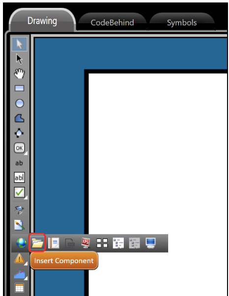
To create a GMapControl component, you need to navigate to the Draw section in the Drawing Tab, and click on Insert Component.
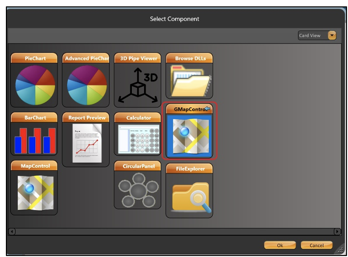
In the popup window, select the GMapControl component, and click on OK.
Note: GMapControl is available only in the .Net display type.
The following settings are a basic way to use GMapControl without using Code Behind.
First, you must import all of the GMapControl proprieties and set some variables.
*	C#:
using GMap.NET;
using GMap.NET.MapProviders;
using GMap.NET.WindowsForms;
using GMap.NET.WindowsForms.Markers;
using GMap.NET.Internals;

double end_zoom;
TGMapControl mapControl = null;
GMapControl gmap = null;
GMarkerGoogle marker = null;
After importing all of the GMap proprieties, you need to configure the mouse and other settings.
All these codes are in method DisplayIsOpening () {}
*	C#:
mapControl = this.CurrentDisplay.GetControl("TGMapControl") as TGMapControl;
gmap = mapControl.GetControlRef();
gmap.DragButton = System.Windows.Forms.MouseButtons.Left;
gmap.CanDragMap = true;
gmap.MarkersEnabled = true;
gmap.Zoom = 11;
end_zoom = gmap.Zoom;
gmap.MaxZoom = 22;
gmap.MinZoom = 0;
gmap.AutoScroll = true;

 * Choice the provider:

gmap.MapProvider = GMap.NET.MapProviders.BingMapProvider.Instance;
Now, we will set the position from the Map and configure the Markers.
*	C#:
	//Set Longitude and Latitude

gmap.Position = new GMap.NET.PointLatLng(-15.793888, -47.883487);

	//Creating Markers

	gmap.Overlays.Add(new GMapOverlay("Markers"));
	gmap.Overlays[0].Markers.Clear();
	gmap.ReloadMap();

addMarker(new PointLatLng(-15.7118595,-47.9107536), GMarkerGoogleType.purple_pushpin,
"DC", String.Format("{0}\n{1}", "DC", "Digital City"));

	addMarker(new PointLatLng(-15.81164,-47.950911),
GMarkerGoogleType.purple_pushpin,
"B", String.Format("{0}\n{1}", "B", "Brasilia"));

addMarker(new PointLatLng(-15.7837743,-47.8957009), GMarkerGoogleType.purple_pushpin,
"NS", String.Format("{0}\n{1}", "EN", "Nacional Stadium"));

addMarker(new PointLatLng(-15.7507488,-47.9370287), GMarkerGoogleType.purple_pushpin,
"NB", String.Format("{0}\n{1}", "NB", "North Brasilia"));
To connect one point to another in the map, use the code below:
*	C#:

	GMapOverlay routes = new GMapOverlay("routes");
	List<PointLatLng> points = new List<PointLatLng>();
	points.Add(new PointLatLng(-15.712199, -47.911240));
	points.Add(new PointLatLng(-15.722334, -47.910331));
	points.Add(new PointLatLng(-15.723553, -47.909480));
	points.Add(new PointLatLng(-15.724644, -47.907717));
	points.Add(new PointLatLng(-15.7411402, -47.9177745));
	points.Add(new PointLatLng(-15.756816, -47.927832));
	points.Add(new PointLatLng(-15.754628, -47.932072));
	points.Add(new PointLatLng(-15.755097, -47.933931));
	points.Add(new PointLatLng(-15.752753, -47.934598));
	points.Add(new PointLatLng(-15.7507488,-47.9370287));

	GMapRoute route = new GMapRoute(points, "DC_NB");
	route.Stroke = new System.Drawing.Pen(System.Drawing.Color.Green, 3) ;
	routes.Routes.Add(route);
	gmap.Overlays.Add(routes);

	points.Clear();
To use small markers in the map without a Big Marker, use this code:
*	C#:

	addMarker(new PointLatLng(-15.772571, -47.937260),
GMarkerGoogleType.green_small, "RE_Y",
String.Format("{0}\n{1}", "RE_Y", "Circuit: yyyy"));

addMarker(new PointLatLng(-15.775202, -47.938166),
GMarkerGoogleType.green_small, "RE_z",
String.Format("{0}\n{1}", "RE_z", "Circuit: zzzz"));
After this, the only thing left to do is to implement the method addMarker () {}
*	C#:
		public void addMarker(PointLatLng position, GMarkerGoogleType tipoPin,
			string tag, string tooltipText)
{
	marker = new GMarkerGoogle(position, tipoPin);

	marker.Tag = tag;
	marker.ToolTipText = tooltipText;
	marker.ToolTip.Fill = System.Drawing.Brushes.Blue;
	marker.ToolTip.Foreground = System.Drawing.Brushes.White;
	marker.ToolTip.Stroke = System.Drawing.Pens.Black;
	marker.ToolTip.TextPadding = new System.Drawing.Size(20, 20);
	marker.ToolTipMode = MarkerTooltipMode.OnMouseOver;

	gmap.Overlays[0].Markers.Add(marker);

  }